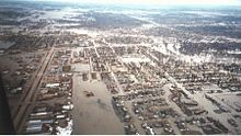
Floodplain definition

The Federal Emergency Management Agency (FEMA) defines the floodplain as the area that would be flooded by a base flood, which is "the flood which has a one percent chance of being equaled or exceeded in any given year". In this sense, a base flood is synonymous with a 100-year flood and a floodplain is synonymous with a special flood hazard area. This base flood "is used in the National Flood Insurance Program (NFIP) to indicate the minimum level of flooding to be used by a community in its floodplain management regulations." FEMA explains regulatory floodplains in some places including hills as "critical determinations are made by evaluating your community’s rainfall and river flow data, topography, wind velocity, tidal surge, flood control measures, building development (existing and planned) and community maps."
Scientists and engineers use statistical analysis of streamflow data to determine the likelihood of flood elevations. Theoretically a 100-year flood occurs once in 100 years and a 500-year flood once in 500 years. However, these expected flood elevations actually occur more or less often than expected.
44 CFR § 9.4 defines parts of the floodplain as follows:
- Floodway means that portion of the floodplain which is effective in carrying flow, within which this carrying capacity must be preserved and where the flood hazard is generally highest, i.e., where water depths and velocities are the greatest. It is that area which provides for the discharge of the base flood so the cumulative increase in water surface elevation is no more than one foot.
- Flood Fringe means that portion of the floodplain outside of the floodway (often referred to as “floodway fringe”).
Comments
Post a Comment